Thanks Omar. Yeah that example has the same issues I’m describing here. If you switch to ellipsoid terrain, scale to 0.1, then the center of the tileset scales as expected (near Brooklyn Navy Yard: 40.706673,-73.977723), but the extremities are floating in the sky (e.g. Orchard Beach: 40.8662867,-73.7943881). If the Orchard Beach Promenade were in it’s own tileset, I’d imagine it would scale correctly.
Another more subtle effect is that scaling causes translation across the earths surface at the extremities. If you swap over to orthographic view and look at Orchard Beach, and switch between scale 1 and 10, you’ll see the promenade shifting its location, which doesn’t happen at the Brooklyn Navy Yard.
What I assume is happening is a uniform scale like classic 3D transformations. Hopefully the following animation explains what I think is happening. The scale is applied along the surface normal at the tileset origin, thus causing the extremities to scale along an axis that doesn’t follow their surface normal. Plus since the extremities are scaled along an axis that don’t follow the surface normal, they shift horizontally too (hopefully shown by the line from the earth’s centre).
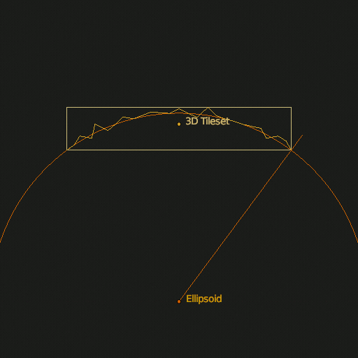
Compare that to this second animation which scales every point along it’s own surface normal (using a deformation cage).

Obviously these examples are exaggerated as we’d be talking about a tileset that covers a quarter of the earth, but when trying to line up multiple tilesets over hundreds of metres or kilometres, they don’t line up when a scaling factor is applied.
To answer your other questions, yes it’s just point clouds exaggerated to highlight subtle differences in elevation.