Hello all,
I’m using MapProxy to create tiles on the client where my webapplication is running the Cesium Globe. I’m pushing tiles from mapproxy tilecache on the globe to show the earth and / or datalayers from PostGIS en Geoserver.
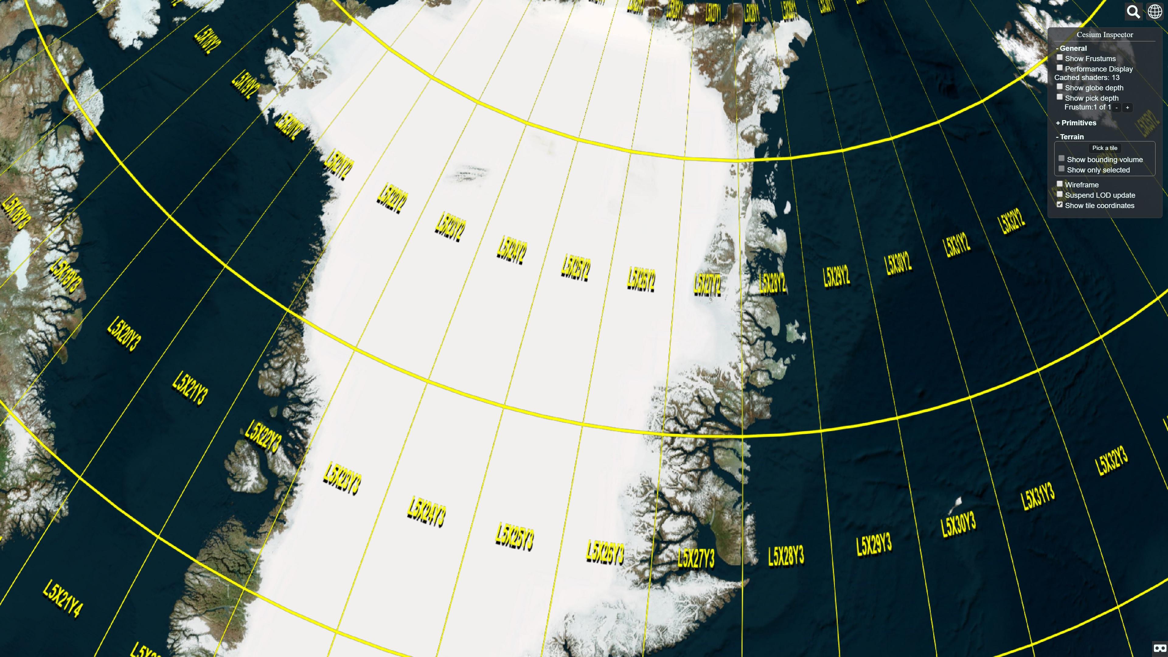
From my BING layer tilecache I get the tiles with a gap between the tiles on the Cesium Globe.
Does anyone knows why?
I’m using: Cesium 1.28.
My MapProxy configuration:
-------------------------------
MapProxy example configuration.
-------------------------------
This is a minimal MapProxy configuration.
See full_example.yaml and the documentation for more options.
Starts the following services:
Demo:
WMS:
WMTS:
Tile service (compatible with OSM/etc.)
TMS:
note: TMS is not compatible with OSM/Google Maps/etc.
KML:
services:
demo:
tms:
wms:
srs: ['EPSG:3857', 'EPSG:4326', 'EPSG:900913']
image_formats: ['image/jpg', 'image/png']
md:
title: MapProxy WMS Server
sources:
esri:
type: tile
url: [http://services.arcgisonline.com/ArcGIS/rest/services/World_Imagery/MapServer/tile/{{z}}/{{y}}/{{x}}.png](http://services.arcgisonline.com/ArcGIS/rest/services/World_Imagery/MapServer/tile/%7B%7Bz%7D%7D/%7B%7By%7D%7D/%7B%7Bx%7D%7D.png)
grid: e_grid
gm:
type: tile
url: [http://mt0.google.com/vt/lyrs=m@0&hl=en&x=%(x)s&y=%(y)s&z=%(z)s](http://mt0.google.com/vt/lyrs=m@0&hl=en&x=%(x)s&y=%(y)s&z=%(z)s)
grid: gm_grid
gs:
type: tile
url: [http://mt0.google.com/vt/lyrs=s@0&hl=en&x=%(x)s&y=%(y)s&z=%(z)s](http://mt0.google.com/vt/lyrs=s@0&hl=en&x=%(x)s&y=%(y)s&z=%(z)s)
grid: gs_grid
ghs:
type: tile
url: [http://mt0.google.com/vt/lyrs=y@0&hl=en&x=%(x)s&y=%(y)s&z=%(z)s](http://mt0.google.com/vt/lyrs=y@0&hl=en&x=%(x)s&y=%(y)s&z=%(z)s)
grid: ghs_grid
gt:
type: tile
url: [http://mt0.google.com/vt/lyrs=t@0&hl=en&x=%(x)s&y=%(y)s&z=%(z)s](http://mt0.google.com/vt/lyrs=t@0&hl=en&x=%(x)s&y=%(y)s&z=%(z)s)
grid: gt_grid
gtalt:
type: tile
url: [http://mt0.google.com/vt/lyrs=p@0&hl=en&x=%(x)s&y=%(y)s&z=%(z)s](http://mt0.google.com/vt/lyrs=p@0&hl=en&x=%(x)s&y=%(y)s&z=%(z)s)
grid: gtalt_grid
gr:
type: tile
url: [http://mt0.google.com/vt/lyrs=h@0&hl=en&x=%(x)s&y=%(y)s&z=%(z)s](http://mt0.google.com/vt/lyrs=h@0&hl=en&x=%(x)s&y=%(y)s&z=%(z)s)
grid: gr_grid
gralt:
type: tile
url: [http://mt0.google.com/vt/lyrs=r@0&hl=en&x=%(x)s&y=%(y)s&z=%(z)s](http://mt0.google.com/vt/lyrs=r@0&hl=en&x=%(x)s&y=%(y)s&z=%(z)s)
grid: gralt_grid
binga:
type: tile
url: [http://ak.t1.tiles.virtualearth.net/tiles/a%(quadkey)s.png?g=5171&n=z](http://ak.t1.tiles.virtualearth.net/tiles/a%(quadkey)s.png?g=5171&n=z)
grid: binga_grid
on_error:
204:
response: transparent
cache: True
502:
response: '#ede9e3'
cache: False
other:
response: '#07232f'
cache: False
bing_meinshiff:
type: tile
url: [http://ak.t1.tiles.virtualearth.net/tiles/a%(quadkey)s.png?g=5171&n=z](http://ak.t1.tiles.virtualearth.net/tiles/a%(quadkey)s.png?g=5171&n=z)
grid: binga_grid
coverage:
bbox: [7.300,52.834,31.192,63.734]
srs: 'EPSG:4326'
on_error:
204:
response: transparent
cache: True
502:
response: '#ede9e3'
cache: False
other:
response: '#07232f'
cache: False
OSM_Borders:
type: wms
wms_opts:
version: 1.1.1
featureinfo: True
req:
url: [http://nas.oculustechnologies.nl:8888/geoserver/wms](http://nas.oculustechnologies.nl:8888/geoserver/wms)
layers: OCULUS:GRP_BORDERS
transparent: true
seed_only: false
OSM_Roads:
type: wms
wms_opts:
version: 1.1.1
featureinfo: True
req:
url: [http://nas.oculustechnologies.nl:8888/geoserver/wms](http://nas.oculustechnologies.nl:8888/geoserver/wms)
layers: OCULUS:GRP_ROADS
transparent: true
seed_only: false
grids:
e_grid:
base: GLOBAL_MERCATOR
origin: ul
gm_grid:
base: GLOBAL_MERCATOR
origin: ul
gs_grid:
base: GLOBAL_MERCATOR
origin: ul
ghs_grid:
base: GLOBAL_MERCATOR
origin: ul
gt_grid:
base: GLOBAL_MERCATOR
origin: ul
gtalt_grid:
base: GLOBAL_MERCATOR
origin: ul
gr_grid:
base: GLOBAL_MERCATOR
origin: ul
gralt_grid:
base: GLOBAL_MERCATOR
origin: ul
binga_grid:
base: GLOBAL_MERCATOR #GLOBAL_WEBMERCATOR
origin: ul
Borders_grid:
base: GLOBAL_WEBMERCATOR
origin: ul
Roads_grid:
base: GLOBAL_WEBMERCATOR
origin: ul
caches:
Roads_cache:
grids: [binga_grid]
sources: [OSM_Roads]
cache:
type: file
directory: d:/tiles/Roads
directory_layout: tms
Borders_cache:
grids: [binga_grid]
sources: [OSM_Borders]
cache:
type: file
directory: d:/tiles/Borders
directory_layout: tms
e_cache:
grids: [e_grid]
sources: [esri]
cache:
type: file
directory_layout: tms
gm_cache:
grids: [gm_grid]
sources: [gm]
cache:
type: file
directory_layout: tms
gs_cache:
grids: [gs_grid]
sources: [gs]
cache:
type: file
directory_layout: tms
ghs_cache:
grids: [ghs_grid]
sources: [ghs]
cache:
type: file
directory_layout: tms
gt_cache:
grids: [gt_grid]
sources: [gt]
cache:
type: file
directory_layout: tms
gtalt_cache:
grids: [gtalt_grid]
sources: [gtalt]
cache:
type: file
directory_layout: tms
gr_cache:
grids: [gr_grid]
sources: [gr]
cache:
type: file
directory_layout: tms
gralt_cache:
grids: [gralt_grid]
sources: [gralt]
cache:
type: file
directory_layout: tms
binga_cache:
grids: [binga_grid]
sources: [binga]
cache:
type: sqlite #file
directory: d:/tiles/BING
#directory_layout: tms
bing_meinshiff_cache:
grids: [binga_grid]
sources: [bing_meinshiff]
cache:
type: sqlite #file
directory: d:/tiles/BING
#directory_layout: tms
layers:
title: OSM_Roads
sources: [Roads_cache]
title: OSM_Borders
sources: [Borders_cache]
title: ESRI World Images
sources: [e_cache]
title: Test of using GM map tiles
sources: [gm_cache]
title: Test of using GM satellite tiles
sources: [gs_cache]
title: Test of using GM hybrid satellite tiles
sources: [ghs_cache]
title: Test of using GM terrain tiles
sources: [gt_cache]
title: Test of using GM alternative terrain tiles
sources: [gtalt_cache]
title: Test of using GM road tiles
sources: [gr_cache]
title: Test of using GM alternative road tiles
sources: [gralt_cache]
title: Bing aerial tiles
sources: [binga_cache]
- name: bing_layer_meinshiff
title: Bing aerial tiles for meinshiff
min_res: 25
max_res: 0
sources: [bing_meinshiff_cache]
globals:
cache:
meta_size: [4, 4]
#image:
# resampling_method: bicubic
#paletted: false
#stretch_factor: 1.15
#max_shrink_factor: 4.0
#formats:
# custom_format:
# format: imaga/png
# mode: RGBA
# colors: 0
# transparent: true


