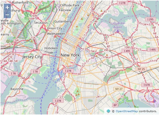
Comparing Cesium to other map viewers like OpenLayers, Cesium 2D maps stand out as having poorer quality basemap rendering. For example, go to this OpenLayers example using OpenStreetMap imagery:
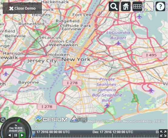
Then open Cesium (e.g. from the default demo on https://cesiumjs.org), select 2D mode from the dimension picker, and select OpenStreetMap from the Imagery picker. Zoom to the same basemap imagery and notice the difference:
In Cesium, the labels and lines are blurry, and the labels are also distorted looking. I love the 3D capabilities in Cesium, but I’d also like a nice 2D map. How can I make the imagery in the 2D mode nice and crisp?
Jacob, continuous zoom plus the fact Cesium projects 2D is the issue. OSM, Bing, ESRI etc don't project the basemaps.
The only way you can make the basemaps match is by working out what height the camera needs to be set at so the resolution matches those resolutions the basemaps have been cached at.
Here is an example of the resolutions you will need to match up:
You will need
Camera.getPixelSize(boundingSphere, drawingBufferWidth, drawingBufferHeight)
and
viewer.scene.drawingBufferWidth, viewer.scene.drawingBufferHeight
and
Camera.getMagnitude()
to work out the work out the requiredHeights. Just remember that as soon as the maps size is changed the heights will have to be recalculated.
This will make the basemaps clearer, but they will never be exactly the same as OSM or Bing
Thanks for the explanation! I can see how projection would be necessary for 3D, but is it necessary for 2D as well? That is, are there Cesium-unique features that require projection even for 2D? Or is this a side effect of optimizing for 3D, and maybe in the future 2D could be enhanced to use whatever rendering approach other maps use to get crisp 2D maps?